Gaia GPS Classic app for iPhone and iPad
4.0 (
1440 ratings )
Travel
Navigation
Developer:
TrailBehind
19.99 USD
Current version:
10.9.16, last update: 7 years ago
First release : 21 Sep 2009
App size: 45.83 Mb
►► WARNING - DOWNLOAD THE NEW APP INSTEAD
Instead of buying this app (Gaia GPS Classic), please download the new Gaia GPS app. You can find it by searching for "Gaia GPS" - then download the app with the gold border called "Gaia GPS: Topo Maps and Hiking Trails."
Were maintaining Gaia GPS Classic for existing users, but our work is focused on the new app.
* * *
Plan trips and explore the wild with Gaia GPS, on your phone, tablet, and computer.
Widely considered the best outdoor mapping app, Gaia GPS has been showcased in Apples "Your Verse" stories, and covered in countless major publications, from Outside and TrailRunner, to the New York Times and FOX News TappedIn.
Top adventure guides use Gaia GPS all over the world.
Since 2009, weve been constantly updating Gaia GPS to help people explore remote places, and stay safer in the woods. Today, many great people contribute to the support and development of Gaia GPS. You can always get in touch with the whole team at [email protected].
Gaia (guy-yuh) comes from Greek mythology - she is the Goddess of the Earth, or Mother Nature.
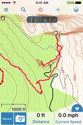
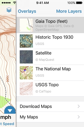
►► Maps
• view maps online at www.gaiagps.com/map
• download worldwide topo, road, and aerial maps
• use Gaias unique, streaming, vector, worldwide topo map
• includes the best government topo maps for the US and Canada (USGS, USFS, NRCan)
• unlimited downloads for offline use - no extra charges
►► Sync, Back-up, and Website
• use Gaia everywhere - iPhone, iPad, iPod, and online at www.gaiagps.com
• sync your tracks, photos, maps, and waypoints to all of your devices
• share links to tracks and photos, via email, Facebook, Twitter, SMS, and more
• keep your data backed up, effortlessly
►► Map Tools
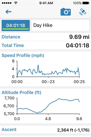
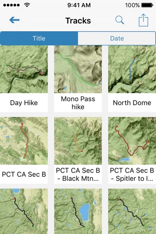
• record tracks, waypoints, and take geo-tagged photos
• display NEXRAD radar, track data, and Gaia POI data with webpages from our search engine
• import and export GPX/KML files, by iTunes, Safari, DropBox, and email
• customize all aspects of Gaia, including units, coordinates types, color and sound, and more
►► GaiaPro
Subscribe to GaiaPro to get extra features, maps, and support. The cost is $5.99/month or $39.99/year.
• use www.gaiagps.com to print maps and plan routes
• download multi-layered maps - mix and set opacity for many layers at once
• use MapBox cloudless aerial and street maps, the best and most up-to-date OpenStreetMap available
• view weather forecasts from Wunderground
• set custom icons for waypoints you create
• sync max-resolution photos to GaiaCloud
To manage your subscription:
• TURN OFF auto-renewal via the main Settings app: http://support.apple.com/kb/ht4098
• Subscription automatically renews unless auto-renew is turned off at least 24-hours before the end of the current period. Your iTunes account will be charged for renewal within 24-hours prior to the end of the current period, and identify the cost of the renewal.
• Payment will be charged to iTunes Account at confirmation of purchase
• Visit the following URL to view our Privacy Policy: http://www.gaiagps.com/gaiacloud-terms/
• Visit the following URL for full terms of use: http://www.gaiagps.com/terms_of_use
►► IMPORTANT - IPOD TOUCH AND WIFI ONLY IPADS - This application will not be fully functional on these devices, unless you have an external GPS attachment. The GPS Recorder and compass will be inactive. You will be able to view maps and waypoints, but you cannot record tracks.
►► GPS WARNING - Continued use of GPS running in the background can dramatically decrease battery life.
Pros and cons of Gaia GPS Classic app for iPhone and iPad
Gaia GPS Classic app good for
Offline maps. Tracking, POIs, export gpx... Best app for tracking your trails.
Good app, but in some situations, it is slow and freezes for a few seconds.
Difficult upload, rectify, export, download and include new map. But it works, and is very much fun!
Its a bit costly, but really worth it. I use it for hiking, cross country skiing and biking for navigation and tracking.
Works great with easy off-line map function. Easy importing GPX files, arrow as waymarker is great to make sure you are moving in the right direction. Also works in bad conditions with very thick cloudy skies. 100% recommandation for people loving to be outdoors
Like Gaia since years!
Great Functions, reliable, good maps! Best for hiking, biking and all Outdoor activities!!!!
Some bad moments
The app does use the location even if the app is not currently running.
Satellite images are not available anymore.
Some Canadian maps not uptodate. Slow loading, even over Wi-Fi.
I have two other offline mapping apps I am using to compare here. Navionics, a boating map and PocketEarth, a roadmap. Both are reliable, quick, vector-based maps and I trust them to cache downloaded maps and display them without connectivity.
Gaia is not like that. First, it downloads bitmaps, which means that the zoom level at which you download is important -it doesn’t scale well up or down afterwards. It is also horribly slow at displaying terrain and often leaves big gaping holes of blank spots. This is my main beef with Gaia - you never quite know if it is displaying something because it cached it or whether it’s just getting off the network. Of course, you can always take it for a hike and find out what it missed ;-)
The other thing is that just gobbles storage space to, again, not cache very much. And, again, especially with the multiple layers, it’s never been particularly easy for me to tell what was actually downloaded where.
If anything, I rely on PocketEarth more when hiking because at least I expect my maps to be available. Yeah, it will be a lot of blank green terrain with few markers of viewpoints. Nothing like a topo map. But at least it will be there and I will have rough idea of my position.
Now, I know that both Navionics and PocketEarth work much better because they can get away with just loading vector, basically numerical data, for sea and roads. Terrain maps have it tougher, it’s not just keeping tracking of roads between cities, you need to track all the elevation and terrain info. So, I appreciate that Gaia has its work cut out.
I just don’t happen to think that Gaia handles it particularly well, sorry.
I have used this app for more than a year. It is not reliable. I never know if it will record a hike or not.
At the beginning it worked but with "upgrades" it has failed repeatedly. I am glad my safety does not depend on it.
The World Imagery Map is unable to provide any usable detail in Ontario, only scales down to 10Km. Topo map alone isnt always helpful to judge the terrain, satellite imagery overlay in greater detail would be quite useful.
Im having trouble with this app. GPS tracking seems to simply stop on its own. Speed indicator shows .2 kph even though Im actually going 55 kph. GPS reception was good because my Tom Tom app worked fine. The maps for New Brunswick, Canada are not good. Missing a lot of roads. The companion web app is horrible. For outdoor GPS, Im beginning to think there is no suitable IOS app. Perhaps a Garmin would be the best way go.
Usually Gaia GPS Classic iOS app used & searched for
trails,
trail maps,
hunting maps,
trail tracker gps,
hunting gps,
trail gps,
trail tracker,
offline maps,
and other. So, download free Gaia GPS Classic .ipa to run this nice iOS application on iPhone and iPad.